|
|
Thank
you for your interest in our charts.
We
originated the laminated fishing chart in Loran-C in 1981 and now
publish them
in both Loran-C and GPS. Due
to
the termination of Loran-C service in 2010, later revisions are being
published in GPS format only, but we will try to keep available for the near
future charts in both Loran-C and GPS format.
Initially, we wrote on them with a grease
pencil, hence the
name “Grease Chart.”
We publish with
our special, copyrighted front-to-back location information index.
- Write on it – wipe it off!
- Waterproof, except when gaffed!
- Puts you on the spot!
|
Currently Available Charts:
(Click the chart title to see a preview image. Image will open in a new window or tab. Close to return to this page)
OFFSHORE CHARTS are
approximately 20”x24” and extend 50+ miles offshore:
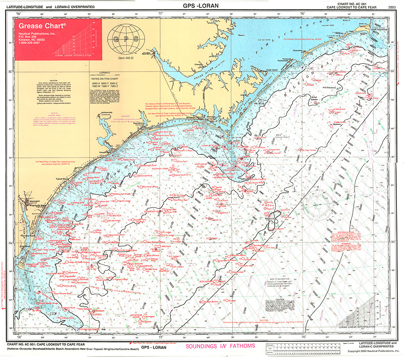
AC 001: Cape Lookout to Cape
Fear (Big Rock Chart) - both GPS and LORAN
AC 001: Cape Lookout to Cape
Fear (Big Rock Chart) - GPS only
AC 002: Cape Fear to Cape
Romain - GPS/LORAN
AC 004: Charleston newly revised and available - GPS only
AC 006: Hatteras-Oregon Inlet - GPS/LORAN
AC 007: Virginia-Cape May - GPS/LORAN
NEAR SHORE / INSHORE CHARTS
are approximately 11”x17” (placemat size, except AC 003 and AC 005) and extend 20+ miles offshore:
AC 001-A: New
River-Swansboro-Beaufort Inlet-Cape Lookout Eastward to 14 Buoy;
Northward to Drum Inlet - GPS/LORAN
AC 001-B: Swansboro-New
River-Topsail-Cape Fear - GPS/LORAN
AC 002-A: Long Bay-Cape Fear,
Lockwood’s, Shallote, Little River, Murrells Inlet - GPS/LORAN
AC 003: Beaufort Inlet,
Shackelford Banks, Back Sound & Cape Lookout on front; Newport
River and
North River Marshes and Cape Lookout enlargement on
reverse side (16"x22") - GPS only -AC003 Temporarily Unavailable-
AC 005: Pamlico Sound-Ocracoke, E-W from Oriental/Neuse River Light to Ocracoke;
N-S from Swanquarter Bay to Cedar Island (21”x 24”) - GPS/LORAN
Pricing
Information:
Offshore (Large) Charts: $19.95 + $1.35 sales tax (NC Residents Only) = $21.30
Near Shore/Inshore (Smaller) Charts: $14.95 + $1.01 sales tax (NC Residents Only) = $15.96
Flat Rate Shipping: $6.75
Buy 3 2 or more
charts, and your entire order ships free!
Online
ordering via PayPal or credit card now available! Use the buttons below
to place your order.

If
you prefer to pay by check, just send a check w/ your order and we will
ship to you right
away:
Make checks payable to:
Nautical Publications, Inc.
Mail to: Nautical
Publications, Inc.
P.O. Box 336, Kinston, NC 28502.
About us: We conceived and originated the first laminated
Loran-C fishing/diving chart in 1981 with the Mobile Bay-Pensacola
"Grease Chart," followed by other Gulf Coast, South Florida and
Mid-Atlantic charts, the latter of which began with the Cape
Lookout-Cape Hatteras Chart (AC001), introduced at the 1983 Big Rock
Marlin Tournament. Ours was the one and only such chart
for a time. We are complimented that our idea has since been
copied by others. More recently, we have produced our charts in
combined Loran-C and GPS formats. With the government's termination of Loran-C service, future revisions will be published in GPS format only.
Why
do we call it a "Grease Chart"? In the summer of 1980, our President and chart
maker attempted to draw a course line on a chart aboard his boat at
Gulf Shores, Alabama and watched the ink disperse into a blue cloud in
the damp paper. That afternoon, when he pulled out his laminated
Alabama driver’s license to cash a check, the light bulb went on:
laminate the chart and write on it with a grease pencil! Today, we use "permanent" marking pens (they don’t
melt) and clean it off with fingernail polish remover (won’t etch the
laminate, also good for removing creosote and grease from rub rails).
Plan your trip- circle your spots- write down your private numbers-
make notes while talking & fishing- wipe it off when you get in:
on your Grease Chart!
Features:
The Grease Chart shows you where to
go and how to get there! A unique feature of the Grease Chart is our
copyrighted key-numbered index to location information on the reverse
side, including Loran-C and GPS coordinates, depths, headings: where to
go and how to get there! We have amassed and update regularly a huge
database of wrecks, reefs, rocks, ledges, holes, canyons, sea mounts,
etc., from commercial/professional fishermen, private fishermen,
government publications and our own, on-the-spot-lines-in-the-water
observations and readings. Information from Artificial Reef
Associations, State-sponsored artificial reef programs, Marine
Fisheries, Sea Grant and other organizations of all published States
has been incorporated and extremely helpful. With
the government's termination of Loran-C service, future revisions will
be published in GPS format only. However, for the convenience of our customers, we will try to keep available for the near
future charts in both Loran-C and GPS format.